SuperMap iServer provides an image service extension module, and the image service provides a new mode of Image Datasets Manager and publishing, that is, to realize the management and rapid publishing of large-scale images or Raster Data through the service (image service). It will change the original way of "Manage Image Data.. And mapping through desktop software, and then publish Image Map" through SuperMap iServer ", which greatly improves work efficiency.
The image service provides the capability of quick Publich Service for massive images, and supports the publishing of multiple Server types: REST, WMTS, WMTS-China, and WMS; the management capability of Image Data, including Add Image, Delete Image, and Query Retrieve Image.
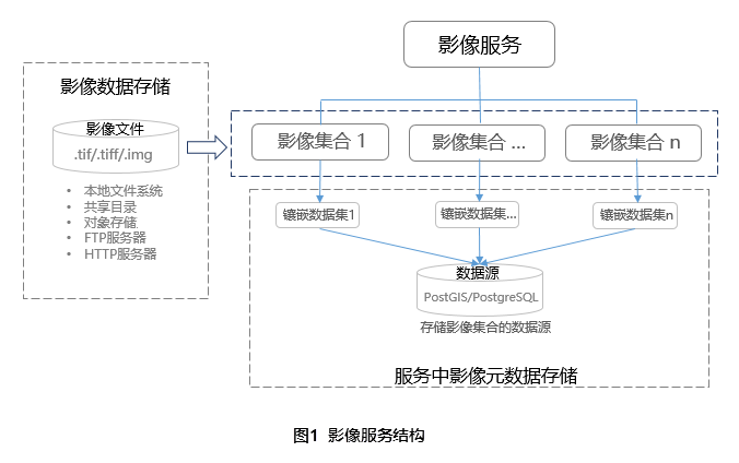
The Image Service uses Image Collections to manage images. Multiple collections can be added to the service.
Image Collection uses the Mosaic Dataset model to manage image metadata, and the corresponding Mosaic Dataset is created when the collection is created.
The collection Mosaic Dataset is stored in the Image Service's Store Datasource for Image Collection, which is specified when the service is created.
When publishing the image service, it is not included to set the Image Data content. After the service is created successfully, add the image through the "Add Image Collection".
The main application scenarios of image services include:
In SuperMap iServer, various storage media (Local File system, object storage system, FTP server, HTTP server, shared directory), Storage Format (.tif.img, .ecw) or Raster Data and the existing Mosaic Dataset results are directly published as image services, and the Data Browse capability is provided. It also supports the modification of the image display style and takes effect in real time. This process does not require desktop software to mosaic and draw Image Data. It greatly improves the efficiency of publishing.
For the application with high frequency of Image Service Data Update, it is most suitable to publish Image Map through Image Service: first, the service publishing is efficient; second, it can monitor the Image Data directory and automatically add new Image Files.
an image or Raster Data is published as an image service, you can retrieve images, Download Data, add, and delete images or Raster Data from the service through the service.
The image service provides WMTS and WMS service interfaces to facilitate the docking of third-party client products and the loading of data managed by the image service.
rapid release can quickly preview the Image Map, but it is not suitable for high concurrent browsing scenes; the image service provides silent slicing capability, and efficiently generates Image Map Tiles in the background, so that the image service has the ability to provide Tile service at the same time.
How to quickly publish an Image Files (.tif or.img file) as an image service and make the service suitable for the above application scenarios, see "Usage Wizard" below:
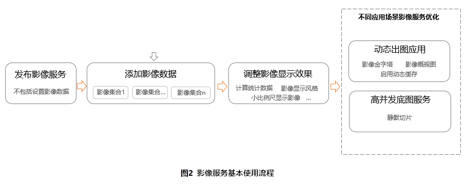
The basic usage process of the image service is shown in the following figure:
Video services can be published in any of the following ways.
Image Data is not included when publishing the image service. After the service is created successfully, add the image through the "Add Image Collection".
After the image service is created successfully, enter the service management page and execute the "Add Image Set" operation to Add Image Data for the service. See:
When the image service Data Update frequency is high, "Auto Append" can be configured at the same time in this link, and the new images in the later period can be automatically added to the service through the monitoring directory.
Image Data You can preview the image after quickly publishing through the two steps of "Publish Image Service" and "Add Image Data".
The adjustment of image display style generally includes: removal of no value, modification of band Combination Display scheme, modification of Image Stretching mode, single-band image display Color Scheme, etc. For details, please refer to:
When the image browsing efficiency is not up to expectations, the corresponding scheme optimization can be adopted according to the application scenario.
Scenario 1: The frequency of Image MapData Update is high, and the number of concurrent accesses is not large. Optimization can be carried out from the aspect of improving the efficiency of dynamic plotting. The factors affecting the efficiency of dynamic plotting and the corresponding optimization scheme are as follows:
Scenario 2: The Image MapData Update frequency is low, but the number of concurrent accesses is large. The pre-slicing method can be used to meet the performance requirements of high concurrent accesses. The optimization scheme is as follows:
1. Image Data addition and deletion:
In the iServer service management page, you can add and delete images by adding and deleting collections. Adding and deleting images from the collection is only possible through the REST API interface.
2. Image Data Support Downloading:
3. Image Data Query Retrieval:
4. Access to image service resources:
The SuperMap iServer image service opens the API to support the Web-side development of the image service management capability. For the image service API, see the "Image" section in the iServer OpenAPI resource structure .
The Image Service API conforms to the STAC (SpatioTemporal Asset Catalog) API specification and provides an OpenAPI-based application programming interface. According to the extension mechanism of STAC-API specification, some new capabilities are added.
According to the requirements of the STAC API specification, the image service API needs to provide the link address of the adopted STAC API specification; in addition, the STAC API specification also adopts some specifications formulated by the Open Geospatial Consortium (Open Geospatial Consortium). The link address of the specification referenced by the image service API is described below.
| Link address | Explain |
| https://api.stacspec.org/v1.0.0-beta.1/core | STAC (SpatioTemporal Asset Catalog-Spatio-temporal Data Asset Catalog) API Core Specification |
| https://api.stacspec.org/v1.0.0-beta.1/item-search | STAC (SpatioTemporal Asset Catalog-Spatio-temporal Data Asset Catalog) API Data Asset Retrieval Specification |
| https://stac-extensions.github.io/projection/v1.0.0/schema.json | STAC Geospatial Reference Extension Specification, which provides a JSON data structure specification that describes geospatial references |
| http://www.opengis.net/def/crs/OGC/1.3/CRS84 | "WGS 84 Longitude/Latitude" geospatial reference specification developed by the Open Geospatial Consortium |
| http://www.opengis.net/def/uom/ISO-8601/0/Gregorian | Time reference system developed by the Open Geospatial Consortium: specification of the Gregorian calendar |
| http://www.opengis.net/spec/ogcapi-features-1/1.0/conf/core | Spatial data access specification developed by the Open Geospatial Consortium |
| http://www.opengis.net/spec/ogcapi-features-1/1.0/conf/html | A standard developed by the Open Geospatial Consortium to describe Spatial Data in HTML format |
| http://www.opengis.net/spec/ogcapi-features-1/1.0/conf/geojson | A standard developed by the Open Geospatial Consortium to describe Spatial Data in GeoJSON format |
| https://spdx.org/licenses/ | List of open source licenses |
| http://commonmark.org/ | Markdown specification |