The image service provides an image query and retrieval page, supports the retrieval of image data in the current service through a variety of query modes, and supports the browsing and data downloading of search result.
Open the image retrieval page
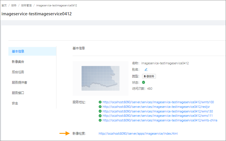
1. Enter the image service management page and click the "Image Search" address.
Configure the base map of the image retrieval page
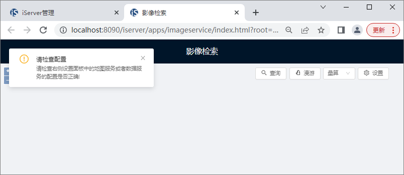
Open the image retrieval page. By default, the Map in the page will load the map service "Map-china400" in the iServer demonstration service as the base map. If the loading fails, the page will prompt the content as shown in the above figure. At this time, it can be configured as required. The specific operations are as follows:
1. On the image retrieval page, click the "Settings" button.
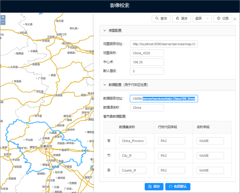
2. In the open panel, complete the parameter settings under "Base Map Coordination".
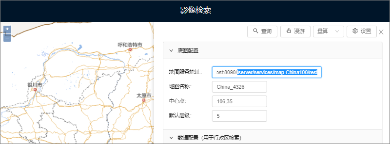
- Map Server Address: Enter the address of a map service as the base map, such as http://localhost:8090/iserver/services/map-China100/rest.
- Map Name: Map service contains multiple maps. Here, you need to specify a specific map, i.e. map name, such as China_4326.
- Center: enter the X and Y coordinates of map center point in the format of X, Y.
- Default Level: Specify the level of the base map default display, which is the level of the Global rule, starting from 0.
3. After the setting is completed, click "Save", the configuration takes effect, and the base map can be loaded.
Configure Administrative Area Retrieval Data Service
If the ability to retrieve image data by administrative division is used (province, city and boundary dataset are used as the query boundary of administrative division), as shown in the following figure, the data service corresponding to administrative division needs to be provided. If you do not use this retrieval method, you can skip this configuration content.
The image retrieval page will load the "data-china400" data service in the iServer demonstration service by default. If the loading fails, the page will prompt. At this time, it can be configured as required. The specific operations are as follows:
1. On the image retrieval page, click the "Settings" button.
2. Complete the parameter settings under configure data in the panel that opens.
- This data service needs to provide the district region dataset of province, city and county, which is used to query the image based on the boundary range of the administrative area, and the property field of the dataset needs to meet certain requirements, which are described in detail below:
- Data Server Address: includes the data server address of the required provincial, municipal and county district region dataset. For example, http://localhost:8090/iserver/services/data-China100/rest.
- Datasource Name: The data service may contain more than one datasource. Specify the name of the target datasource, such as China.
- Provincial Region Dataset Name: for example, China_Province_pg, and the provincial region dataset needs to include the administrative code field and the administrative region name field, which are specified separately in the "Administrative Code Field" and the "Name Field" in the panel.
- Municipal Level Dataset Name: For example, City_R, and the municipal region dataset needs to include the administrative code field and the administrative region name field, which are specified in the "Administrative Code Field" and the "Name Field" in the panel respectively.
- County Region Dataset Name: For example, County_R, and the city region dataset needs to include the administrative code field and the administrative region name field, which are specified separately in the "Administrative Code Field" and the "Name Field" in the panel.
3. After setting, click "Save", and the configuration will take effect.
Query Image Data
Image retrieval supports the retrieval of image data in the current service through various query modes.
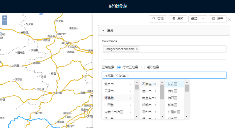
1. On the image retrieval page, click the "Query" button to open the query panel.
2. In the query panel, set Query Conditions:
- Image Collection Condition (Collections): Query in the specified image collection. Multiple collections can be specified; if not specified, images will be retrieved in all collections in the service. If multiple image collections in different coordinate systems are specified, the query involving geographic range will use the coordinate system of the first collection as the reference coordinate system for range query.
- Administrative region search: search images according to the designated provincial, municipal and county-level administrative regions. This query conditions is not available until the Administrative Region Retrieve Data Service is configured.
- Rectangle retrieval: Draw a temporary rectangle to determine the query range and retrieve the images within the range.
Note: Administrative area and rectangle retrieval are based on geographic range. If both are set at the same time, the rectangle range will be used as the retrieval range. Image collection and geographic range conditions are valid at the same time.
3. After setting the Query Conditions, click the "Query" button to obtain the search result.
As shown in the figure below, it is demonstrated to query the images of the collection of an image service "chinatiff4490".
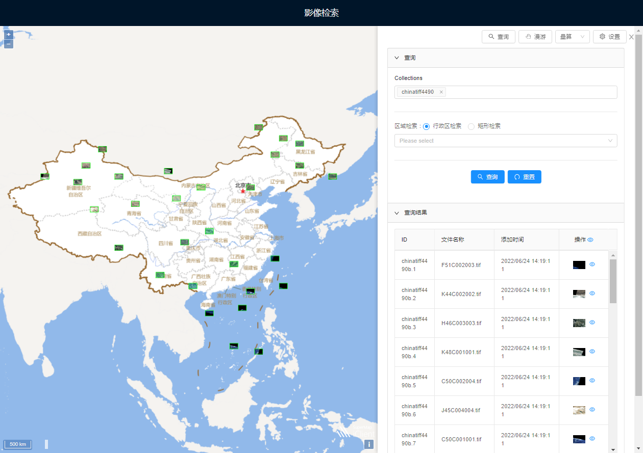
View the search results
The Search Result consists of two parts, as shown in the figure above:
- First, the outline of result image will be displayed in map and the image can be browsed.
- Second, the right panel will display result image records, one for each image.
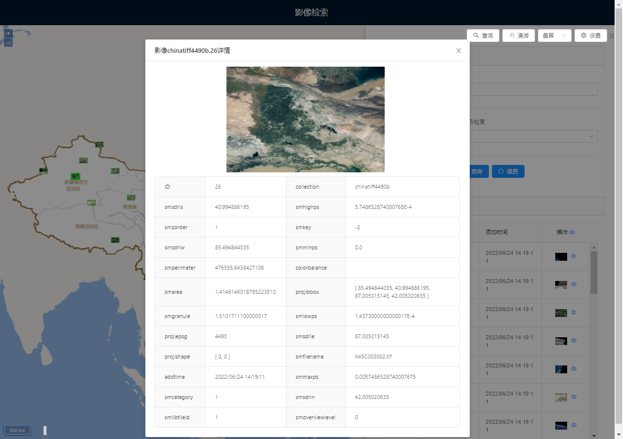
1. In map, click the image outline to view the details of the selected image, as shown in the following figure:
2. In the result image record, when move Stop by mouse to a record, map will also highlight the corresponding image outline.
3. In the result image record, open the display status button on the right side of the image record. Map will display the corresponding image and can be browsed.
4. Image collection is configured with downloadable data. The following icon will appear for the result image record, and the corresponding image files can be downloaded. For data downloadable configuration, please refer to Configuring Image Service Data Downloading Capability .