iClient JavaScript |
SuperMap iClient JavaScript is a new and open source space information and services visual interactive development platform. It is the united JavaScript client of SuperMap server and online GIS platform. Support multiple source data map; support multi-terminal and cross-browser. This product can quickly realize the beautiful and smooth map rendering of the browser.
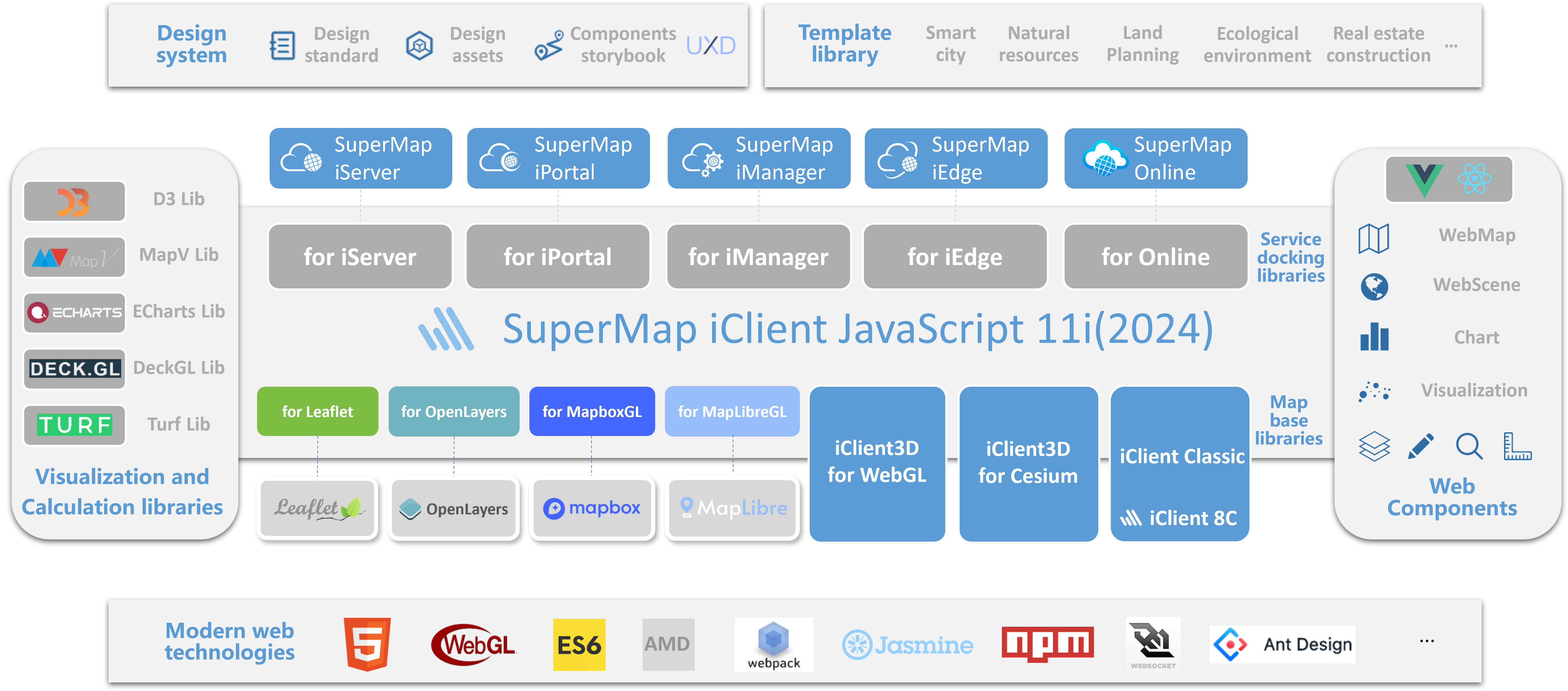
SuperMap iClient JavaScript integrates Leaflet, OpenLayers, MapboxGL JS and MapLibreGL four mainstream JavaScript library packages for developing WebGIS clients. Provide iClient for legacy (SuperMap iClient for JavaScript 8C compatibility module), which helps you to implement version upgrade and migration easily. At the same time, it integrates the common mainstream chart library of ECharts, D3 and MapV. Presents a richer variety of visualizations.

SuperMap iClient JavaScript 2025 System Diagram
SuperMap iClient JavaScript 2025 can provide:
Provides the visualization of common thematic maps, including dot density thematic map, unique thematic map, range thematic map, graduated symbols thematic map, label thematic map and chart thematic map
Provides consistent Web symbolic mapping capabilities at the front and back ends, and support to custom Web symbol
Provides geometry analysis API based on SuperMap UGC and WebAssembly technology, applying to front-end and off-line analysis
Support to access SuperMap iServer services, including map service, data service, spatial analysis service, network analyst service, traffic transfer analyst service, plotting service, distributed analysis service, address matching services, dataflow service, web printing service, geoprocessing service, image service, etc
Provides the Elasticsearch time series thermodynamic diagram and flight monitoring visualization
Support the Mapbox vector tile standard. Provide more map styles and client free change styles
Support 10W+ point elements are effectively and smoothly drawn on the browser side
Integrate common visualization effects of ECharts and ECharts GL, including 2D scatter map, migration diagram, thermal diagram, line drawing, cell map, point/line effects map, common charts, and 3D scatter plots, flying lines, histograms, surface maps, etc
Integrate the data visualization open source library MapV. Provide honeycomb diagrams, commuter maps, strong border maps, migration maps, dynamic trajectory maps, surface rendering, line-drawing, and mapping of massive amounts of data
Integrate the large data volume visualization framework DeckGL. Provide path map, honeycomb map, commuter maps, contour map, polygon map, time series variation map
Integrate the data visualization open source library AntV L7. Provide wind field map, path map, label map, aggregation map, 3D map, particle map, etc
Integrate the 3D drawing JS library threejs to realize the loading of gltf model and obj model
Intergrate the visual javascript library D3 to support D3 visualization layer
Integrate the OSMBuildings to realize visualization of architectural stereo effect
Provides a cache switching control to support multi-version cache switching on the client side
Quick access to user configured maps in SuperMap iPortal and SuperMap Online
Uniform the security authentication interface of SuperMap iServer, SuperMap iPortal and SuperMap Online. Support secure login and to access maps or services with token or key
For more information, please refer to SuperMap iClient JavaScript online: http://iclient.supermapol.com/. Get the develop package, please refer to GitHub: https://github.com/SuperMap/iClient-JavaScript or GITEE: https://git.oschina.net/isupermap/iClient9.