Image Data |
SuperMap Realspce supports *.bmp, *.gif, *.jpg, *.png, *.tiff format to generate the image data which can be loaded to the 3D scene, and according to the coordinate reference information of the image data, the image data is added to the surface of the sphere in the 3D scene. The image data here includes an image data set (sit), a raster map data set, and corresponding 2D and 3D image cache data (sci, sci3d), and 2D and 3D map cache data (sci, sci3d). The iServer supports the 2D and 3D image cache data (sci, sci3d) stored in the block format as the data source, and its publish services method is similar to that of the ordinary 2D and 3D map or image cache (sci, sci3d). For image/raster map data, since the amount of data is usually large, the speed of data loading and browsing is generally improved by pre-caching during service publishing, that is, the data is saved in SuperMap image data on the server side of iServer has been preprocessed.
The principle of image/raster map data cache is to tile the data to generate tile data, name it according to certain rules, and store it in the corresponding cache folder. At the same time, the system will generate a *.sci3d under the cache root directory. An index file of the format. The tile data is generally in PNG, GIF, and JPG formats, and the *.sci3d file is a file that records the image/raster map data cache information, that is, the configuration index file of the image/raster map cache data file. When the user loads the image/raster map cache data in the 3D environment, the corresponding data can be loaded by loading the index file of the image/raster map cache, and the loading and browsing efficiency of massive image data and raster map data can be greatly improved by using the image/raster map cache. It is worth noting that since version 10.1.0, after maps and image data in sci format are published as 3D service, iServer will automatically and dynamically convert them to sci3d format.
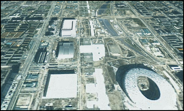
As shown in the figure below, they are respectively the cached images of format after the remote sensing image and map data are loaded into the 3D scene and published as 3D service.
In order to improve the data transmission speed and reduce the data transmission amount, regarding the format of tile data in the image cache, SuperMap 3D service measures the advantages and disadvantages of JPEG and PNG file formats and provides a mixed format image caching method. Among them, JPEG image format (*.JPG, *.JPEG) is a commonly used format, which is a lossy compression format. It can compress images in a very small storage space, and its compression function is particularly powerful. PNG (*.png) format is the most popular file format in WEB applications, it supports high-level lossless compression and can provide uncompressed image files with a length 30% smaller than GIF. Compared to JPEG's lossy compression, PNG Provides a smaller amount of compression, but can keep the edges transparent or translucent.
Based on the above features, SuperMap 3D service provides JPEG + PNG mixed mode cache, allowing users to use in the same cache. Tiling of both JEPG and PNG image formats. Users can choose to apply the JPEG format to the tile located in the middle of the cache in order to reduce the size of the relevant file, and apply PNG format on the periphery of the cache (i.e. this part of the slice needs to remain transparent). This hybrid mode takes into account the advantages of both JEPG and PNG formats. The cache file not only maintains the advantage of JPEG that occupies a small disk space, but also makes the whole image displayed without being affected by the edge of the cache tile, which can effectively reduce the disk space occupied by the cache file and improve the transmission speed of the image data.