Aggregate Points |
Aggregate Points refers to creating an aggregation map based on a point dataset. First, it separates the points on the map with grids or regions. Secondly, it calculates the number of the points in each region or grid and take it as the statistical value of the region or grid. It can also use weighted field of points as the statistical value of the region or grid. At last, it fills the regions or grids with graduated color.
Aggregate Points in iServer includes: Aggregate with Grid and Aggregate with Region. The grid type can be square or hexagon.
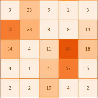
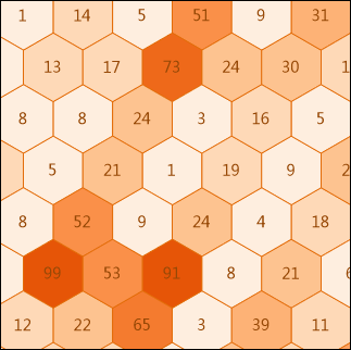
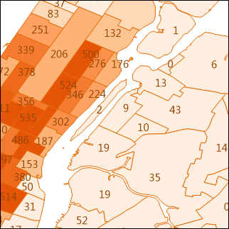
Fig 1: Aggregate with Square Fig 2: Aggregatie with Hexagon Fig 3: Aggregatewith Polygon
Source dataset: Required. It only supports point dataset. The aggregatepoints resource page in iServer will list the datasets which meet the analysis condition.
Aggregate type: Required. It includes grid and region.
Range: Optional. It specifies which points to be processed. The default is the full map range.
Weight fields: Optional. The weight field collection, and the format should be like: col7,col8
You can specify multiple weight fields separated with comma to perform multiple analysis operations, each time it corresponds to a different weight value.
If this parameter is null, 1 will be taken as the weight value.
Whether the parameter is set or not, the condition when the weight value is 1 will be analyzed, which is to take the number of the points as the statistics value of the region. The result will be saved in the attributes field in the result dataset.
If this field is set, the statistical modes should be set too, and the two should correspond to each other.
Statistical modes: Optional. Supported modes include: max, min, average, sum, variance, stdDeviation. The field should be have the same count with the count of the Weight fields.
If you choose Aggregate with Grid, it also needs to set the following parameters:
Grid type: Required. It includes square and hexagon.
Grid size: Required. It is the edge length for a square and the distance from the vertex to the center of the hexagon for a hexagon. The default value of grid size is 10.
Grid size unit: Optional. Options include: Meter, Kilometer, Yard, Foot and Mile (default is Meter)
If you choose Aggregate with Region, it also needs to set the following parameters:
Aggregation region dataset: Required. Its type should be region dataset. Aggregation region dataset is used to specify to the region objects used to aggregate the input points, such as administrative division regions.