
Carry out multiple classification on that image, namely analyzing by utilize the spectral information of various ground objects in the remote sensing image and spatial info, and respectively endowing each pixel with semantic information in the image with a semantic category label to realize the multiple classification, including buildings, forest land, grassland, paddy field, agricultural land, etc.
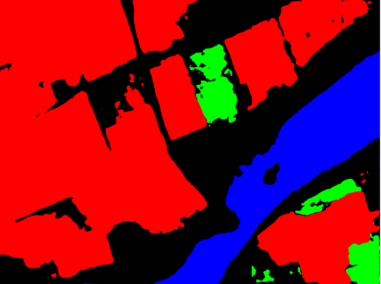
Figure 1: Original Image Figure Figure 2: Classification results of ground features (buildings, green spaces, water bodies)
Image Data Source: Required parameter; specify the datasource path of Image Dataset for analysis, such as C:\Data\Image.udb. Currently, only udb, udbx, and tiff formats are supported. It can also be specified by selecting a registered dataset.
Image Dataset: Required parameter, specifying the image dataset name word to be analyzed, such as dsm. When the input data source is tiff, this parameter does not participate in the analysis.
Model File: Required parameter, which is the path of the trained model file for analysis, such as C:\Data\models.sdm. It can also be specified by selecting a registered model.
Slice Offset value: Optional parameter, the offset pixel value of the image slice (in the process of multiple classification, due to the structural characteristics of the convolutional neural network, the data prediction of the slice edge will be insufficient, and in order to improve the prediction quality, the slices need to be overlapped). This parameter is in the unit of pixel. The default value is 0.
User-defined Result Datasource Name: Optional parameter. Check this option to specify the datasource name stored in analyst result, such as Result. Datasource will be created when it does not exist.
Result Dataset: Optional parameter, output multiple classification resulting dataset name. The default is the multiclassify_result.
Publish Result as Map Service: Check this option to publish multiple classification result as map service.
Publish Result as Data Service: Check this option to publish multiple classification result as data service.