Common Elements |
In SuperMap iServer WCS service, all of the operation may use GET request with KVP encoding.
In SuperMap iServer WCS service, all of the operation response in the XML format. The operation responses shall avoid special characters such as “<”,“>”,“--”,“?” and “=”. If you need to use these characters, use the corresponding escape characters to replace them.
Table 1 Parameters in GetCapabilities operation request
|
Reserved character |
Escape character |
|
< |
< |
|
> |
> or > |
|
-- |
|
|
? |
%3F |
|
= |
|
WWCS operation requests and responses frequently references to a defined Coordinate Reference System (CRS), and sometimes include a CRS definition. A defined CRS is required for spatial referencing by coordinates, and the specified spheroid.
In a Bounding Box data structure, the LowerCorner defines the edges of the (available or requested) region in the directions of decreasing coordinate values in a CRS (normally the algebraic minimum coordinates), and the UpperCorner defines the edges in the directions of increasing coordinate values (usually the algebraic maximum coordinates).
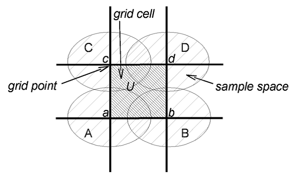
For continuous (interpolatable) grid coverages, these values shall be computed from the areas of all the (available or requested) coverage grid cells with all corners at recorded grid points.
WCS considers only grids whose points lie at the corners (not the centers) of the grid cells. This document thus primarily considers continuous grid Coverage, not discrete grid Coverage. As illustrated above, grid points (a, b, c, d) define a grid cell (U). The layer extent of a grid Coverage is decided by the furthest grid points in the BoundingBox, not the grid cells.
In a geographic CRS, longitude values are often defined with a finite extent (e.g., from -180 degrees to +180 degrees) and the minimum and maximum longitude limits define a single line (on the ellipsoid, sphere, or cylinder), known as the antimeridian. As longitude values are discontinuous, longitude changes abruptly (e.g., going West from a little more than -180 degrees to a little less than +180 degrees). This requires an "extended" continuous of the BoundingBox. This necessitates an extended interpretation of the Bounding Box definition:
A Bounding Box defined in a geographic CRS (or a WGS84BoundingBox) whose LowerCorner longitude is greater than that of its UpperCorner shall describe a region that crosses the longitude discontinuity.
For example, a bounding region encompassing the Pacific Ocean could be described by a BoundingBox with a positive LowerCorner longitude and a negative UpperCorner longitude.